

This animation shows the melting of Arctic sea ice from 1 June to 24 August 2011.
Every year, the Arctic Ocean experiences the formation and then melting of vast amounts of floating ice, but the rate of overall loss has accelerated.
Credits: Animation based on data from the US National Ice Center
Satellite measurements show we are heading for another year of below-average ice cover in the Arctic. As sea ice melts during the summer months, two major shipping routes have opened in the Arctic Ocean.
In 2008 satellites saw that the Northwest Passage and the Northern Sea Route were open simultaneously for the first time since satellite measurements began in the 1970s – and now it has happened again.
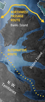 | |
Ice-free Northwest Passage |
Located in the Canadian Arctic Archipelago, the Northwest Passage can be a short cut for shipping between Europe and Asia – but with the opening of the sea route comes the potential for both sovereignty claims and marine species migration across the Arctic Ocean.
In 2007, Arctic sea ice hit a record low since satellite measurements began nearly 30 years before. That same year, the historically impassable Northwest Passage opened for the first time.
Unusual weather contributed to 2007’s record ice loss: skies opened over the central Arctic Ocean and wind patterns pushed warm air into the region, promoting a strong melt.
Weather patterns have been different this year, but the early opening of the passages indicates that we could be about to hit a new record low in ice cover.


No comments:
Post a Comment